Geospatial Intelligence in Urban Planning and Development
We provide advanced geospatial solutions for land governance, urban modeling, and smart city applications — enabling ministries and authorities to plan more effectively and sustainably.

Core Services
- Land & Property Management – Digitized land governance and property systems.
- Geospatial Modeling – Simulations for growth, infrastructure, and environmental impacts.
- Data Management & Analysis – Processing, integrating, and visualizing large geospatial datasets.
- Geospatial AI & Innovation – Machine learning and predictive modeling for smarter insights
Applications for Government Planning
- Site selection and land evaluation
- Market and demographic analysis
- Land-use restructuring and dynamic master plans
- Urban project monitoring and risk management
- Environmental impact assessment
- Smart city services: traffic, emergency response, public safety, and sustainability

Geospatial Intelligence Key services for urban planning:
- Data collection and analysis: Gathering and analyzing data on land use, infrastructure, demographics, and other factors critical to urban planning.
- Map production: Creating visual maps that help urban planners understand spatial relationships within the city or study area and help decision-makers see the urban landscape clearly to make the best development decisions.
- Spatial modeling: Building models that simulate the impacts of urban change on mobility, air quality, and water availability.
- Government stakeholder engagement: Involving different government entities through all development stages, according to each project’s nature, to ensure quality and sustainability through integrated action towards a brighter, more sustainable future.
- Performance dashboards: Producing dashboards with spatial and digital indicators for the relevant development areas to make reading the urban and informational landscape easier.
- Community engagement: Creating interactive maps and tools that enable the local community to provide feedback on proposed projects and plans.
These geospatial services provide governments with valuable tools for urban planning, enabling sustainable and equitable decisions that benefit all parties.
Geospatial Intelligence for Smart Cities — Main Applications
- Spatial data management: processing and analyzing large volumes of geospatial data.
- Infrastructure planning: optimizing the distribution of sensors, cameras, and wireless networks.
- Traffic management: improving traffic flow using smart signals and dynamic routing.
- Emergency response: planning optimal routes for emergency vehicles.
- Public-safety analysis: studying crime patterns to support law-enforcement agencies.
- Sustainability planning: monitoring air and water quality and energy consumption.
Geospatial Intelligence in Urban Planning — Practical Uses<br />
Geospatial intelligence is an essential tool for future-oriented urban planning. It supports decisions about site selection, market analysis, land evaluation, land-use restructuring, urban project management, and environmental impact assessment:
- Site selection and land evaluation: Analyzing candidate sites based on location, proximity to transport, and surrounding environmental characteristics to determine the most suitable land for residential, commercial, or recreational uses—improving planning quality.
- Market analysis: Studying demographic and population trends to identify areas with growing demand for urban services and facilities, informing strategic land-allocation decisions that meet the needs of residents and investors.
- Land-use restructuring: Enabling planners to update and restructure base maps and approved master plans (land-use maps) dynamically to adapt to future changes, while complying with ministerial regulations, surrounding environmental considerations, and evolving community needs. This achieves a balance between sustainable development and future urban growth and ensures sustainable integration with infrastructure and services, as well as the surrounding environment, in a smart and flexible manner.
- Future project management: Monitoring the execution of urban projects by tracking progress, budgets, and potential issues or delays—improving project management and reducing risks to ensure efficient, effective delivery.
- Environmental impact assessment: Before launching any planning project, geospatial intelligence is used to analyze potential environmental impacts—supporting compliance with environmental regulations and reducing negative effects on the environment to foster sustainable urban communities.
Geospatial AI and Innovation in Urban Planning
Service definition:
Artificial intelligence is used to develop innovative, rapid solutions based on geospatial technologies to address urban-planning challenges and improve associated processes.
Overview:
This service integrates AI with geospatial technology to deliver data-driven solutions capable of addressing complex urban challenges. Through advanced spatial analysis, predictive modeling, and machine-learning techniques, we provide strategic insights that enhance planning quality, strengthen decision-making, and support sustainable growth in cities. By leveraging geospatial intelligence, urban planners can obtain precise insights that support effective planning and improve the management of urban and environmental projects.
AI-enabled capabilities:
- AI-powered geospatial analytics: Interpreting massive geospatial datasets to reveal hidden patterns and trends that influence strategic decisions.
- Specialized solutions: Developing applications and tools tailored to each industry to achieve organizational goals and overcome sector-specific challenges.
- Real-time insights: Delivering interactive dashboards and live monitoring tools for real-time decision-making, backed by high-speed data processing.
- Predictive modeling: Analyzing future trends and forecasting risks and opportunities by combining historical geospatial data with AI-based predictive analytics.
- Automation and optimization: Improving workflows, resource management, and logistics planning using AI algorithms to boost operational efficiency.
Service-delivery approach:
- Assessment & Planning: Understanding business challenges and defining objectives.
- Data Integration: Collecting geospatial and business data and integrating them into analysis models.
- Model Development: Building specialized AI models for geospatial problems.
- Solution Deployment: Implementing tools within current workflows or as standalone solutions.
- Support & Enhancement: Providing ongoing support, model improvements, and updates to ensure value realization.
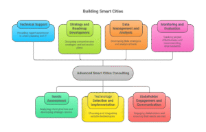
Technical Support
Comprehensive technical support by specialized experts in urban planning and information technology serving all government entities in the Kingdom of Saudi Arabia (e.g., regional development authorities, municipal secretariats, relevant ministries, and Public Investment Fund companies).
Needs Assessment
- Analyzing the priorities and needs of government clients in the Kingdom.
- Developing a strategic vision for their smart city initiatives.
- Holding consultations with key stakeholders, reviewing current plans and strategies, and analyzing data related to urban trends and challenges.
Strategy and Roadmap Development
- Designing a comprehensive strategy for smart city initiatives.
- Identifying key focus areas such as mobility, sustainability, and public safety.
- Developing actionable work plans for each area to ensure effective implementation and full coordination.
Technology Selection and Implementation
- Helping clients choose the most suitable technologies for smart city initiatives.
- Providing guidance on implementation and systems integration.
- Evaluating vendor solutions, preparing technical specifications, and supervising procurement and execution.